MOST
MOST – “National Center for Sustainable Mobility” is one of the programs funded under the National Recovery and Resilience Plan (PNRR) – Mission 4, Component 2 (M4C2). Through collaboration with 24 universities, the National Research Council (CNR), and 24 major companies, its mission is to encourage and support the development of modern, sustainable, and inclusive solutions across the entire national territory.
Among the major companies involved is TAS-I, particularly within SPOKE#9 – Urban Mobility. In this context, TAS-I has established a collaboration with CORISTA. The objective of the activities assigned to the consortium is the study and development of innovative radar technologies for traffic monitoring in urban scenarios. The program aims to explore the feasibility of developing a radar sensor capable of providing information on moving vehicles (MTI) and mapping changes in the observed scene over time.
CO.RI.S.T.A., in collaboration with the university consortium partner, has focused on the development of a ground-based radar system based on Software Defined Radio (SDR) technology and on algorithms (DOA and Inverse SAR) for the detection of moving objects.
The activities, which began in May 2024 and will last 20 months, include a design and implementation phase for the system and data processing algorithms, followed by a field testing phase.
Echo Simulator System - Real Time (ESS-RT)
As part of the ExoMars Rosalind Franklin mission, scheduled for launch in 2028, TAS-I has entrusted CORISTA with the development of the Echo Simulator System – Realtime (ESS-RT).
The ESS-RT will be used as part of the ExoMars Electrical Ground Support Equipment to test, integrate and operate the Radar Doppler Altimeter (RDA) instrument on-board the Entry, Descend and Landing Module (EDLM). The EDLM will be part of the ExoMars Rosalind Franklin Mission.
The Radar Doppler and Altimeter (RDA) is the instrument that will support the to land on the Mars surface. The RDA is used during the descent phase to support the descent module control. It is therefore conceived to support the EDLM Guidance, Navigation and Control (GNC) by estimating descent altitude and speed.
The RDA is based upon a pulsed Continuous Wave (CW) radar approach and forms four independent narrow beams illuminating the Mars surface, steered in proper angular directions.
To test RDA, The Echo Simulator System shall implement the following tasks:
- interface the RDA RF section
- simulate the echo generated by interaction between the RDA transmitted signal and martian surface
- cover the GNC closed loop test (RDA in the loop): the echos shall be generated in real time from the input data (EDLM state vector) coming from the GNC Special Checkout Equipment (SCOE);
- allow remote Command and Control from Central Checkout System.
The project, which began in February 2025, is structured in two main phases: an initial phase dedicated to the definition and detailed design of the ESS-RT, followed by a second phase focused on the development, integration, testing, and verification of the ESS-RT, concluding with the delivery of the test equipment scheduled for the end of 2026.
JUICE – RIME
ESA’s Jupiter Icy Moons Explorer, Juice, launched the 14th April 2023, will make detailed observations of the giant gas planet and its three moons – Ganymede, Callisto and Europa – with a suite of the state-of-the-art instruments.
RIME is a low-frequency radar sounder designed to detect the characteristics of the surface and subsurface of celestial bodies. It was designed to measure the interior of Jupiter's icy satellites namely Ganymede, Europa and Callisto. These measurements have never been made before on Jupiter's Galilean moons. In addition to the study of the geology of Ganymede, Europa and Callisto, the radar has the unique ability to detect the possible presence of pockets of water in the subsurface layers. This is of particular importance for the entire mission since the main objective of JUICE is to understand the conditions of habitability of the icy moons. The instrument was built by a consortium of institutions led by Thales Alenia Space (Rome) under the responsibility of the Italian Space Agency (ASI) and with the contribution of NASA's Jet Propulsion Laboratory under the scientific leadership of the University of Trento.
CO.RI.S.T.A. has been involved in RIME activities since its design and continues even now that JUICE is on its way to Jupiter. CO.RI.S.T.A. initially participated in defining the instrument specifications so that it would meet the scientific requirements of the mission. This was followed by design, testing and validation activities up to the launch. After the launch, CO.RI.S.T.A. was first involved in commissioning activities and is still providing support for data analysis and monitoring of the instrument during cruising.
EnVision – RS
EnVision will be ESA’s next Venus orbiter, providing a holistic view of the planet from its inner core to upper atmosphere to determine how and why Venus and Earth evolved so differently.
EnVision was selected as ESA’s 5th Medium-class mission in the Agency’s Cosmic Vision plan, targeting a launch in 2031. The mission was adopted in January 2024, and ESA awarded Thales Alenia Space (TAS) the contract to build the Envision spacecraft on January 28 2025.
The objective of EnVision is to use the observations of the different parts of the Venus system to studying the planet's history, activity and climate. This will be achieved by its five instruments, provided by European and US research institutes and space agencies. EnVision aims to characterize Venus’ core and mantle structure, to detect signs of past geologic processes, and to look for evidence of past liquid water. Recent modelling studies strongly suggest that the evolution of the atmosphere and interior of Venus are coupled, emphasizing the need to study the atmosphere, surface, and interior of Venus as a system.
The Subsurface Radar Sounder (SRS) is a nadir-looking radar sounder instrument, which transmits low-frequency radio waves with the unique capability to penetrate into the subsurface. When these radio waves travel through the subsurface, their reflected signal varies in power through the interaction with subsurface horizons and structures representing dielectric discontinuities. These varying reflections are detected by the radar sounder and used to create a depth image of the subsurface (referred to as radargram) and so map unexposed subsurface features. The design of the SRS instrument depends on the physical and electromagnetic modelling of the surface and subsurface targets.
CO.RI.S.T.A. is currently participating in the phase of defining the requirements and specifications of the tool. The design and implementation activities in the B2/C1 phase of the tool have recently begun.
IRIS project
In the frame of ESA IRIS SATCOM GLOBAL SOLUTION, CORISTA has started its collaboration with TAS-I for IRIS Payload Development Model Test Bed activities. The test bed scope is to estimate IRIS payload performances.
CORISTA is in charge of design, develop, and deploy the E2E Verification Facilities, namely the up-link and down-link signal sw emulator.
The E2E Verification Facilities is composed of two main modules named as follows:
- Waveform Generator and Analyzer (WGA);
- Channel Emulator (CHE).
The WGA will assist the generation of the modulated waveform signal toward the transmitted section (up-link), and will enable the demodulation of the received signal at the receiving section (down-link). The CHE will allow the characterization of the channel’s effects (Doppler Shift, Propagation Delay etc.) for the transmitting and receiving paths.
The E2E Verification Facilities has two main interfaces with test bed which are the Arbitrary Waveform Generator (AWG) and the Digitizer. The E2E Verification Facilities will produce a data file as output towards the AWG, containing the timing processing of both the WGA TX and CHE TX modules, and will receive a data file as input from the Digitizer, which includes both the Payload Model processing and CHE RX data.
CORISTA Activities has started on June 2023 and will end on June 2025.
OCEANOS project
“OCEANOS - - Monitoraggio coltivazioni e zone marine costiere: Tecnologie Satellitari di nuova generazione” project is funded with by PON/MIUR call n°1735 of 13 July 2017 “Notice for the presentation of industrial research and experimental development projects in the 12 areas of specialization identified by the 2015-2020 PNR".
OCEANOS project is led by Thales Alenia Space in Italy.
OCEANOS project aims to provide an integrated system, based on a set of systems and services, which by exploiting different technologies and methodologies, can answer to the needs of different users (institutional and/or commercial), guaranteeing different performances in terms of availability, information and response times, as well as different cost targets.
The project has several objectives: the development of advanced SAR antenna technologies, which allowo obtain high performance with satellites of reduced mass and size; the development of compact radar sensors and electro-optical sensors to be integrated on board drones; the development of advanced data post-processing algorithms, and the development of an encryption system (ground-edge) for the protection of commercial satellite communications.
As part of the project, a SAR antenna prototype will be developed, including radiant panels and amplification electronics, on which functional tests will be carried out. Acquisition campaigns will also be carried out in the Calabria region, with compact radars integrated on drones (provided by the Calabria Civil Protection).
As regards data post-processing, the objective is to develop appropriate algorithms to obtain hydrogeological information, presence and classification of vessels, slow and small movements of critical infrastructures. Two parallel activities are envisaged: on the one hand algorithms will be developed and validated for the analysis of data acquired during measurement campaigns with drones, and on the other hand algorithms will be developed for the analysis of multi-frequency SAR images (in X and C band, acquired by Cosmo Sky-Med and Sentinel-1/Radarsat 2).
Project team composition
- Thales Alenia Space Italy (Prime)
- University of L’Aquila
- University of Calabria
- University of Rome “La Sapienza”
- University “Tor Vergata”
- TAIPRORA
- CORISTA
- Techno System Developments (TSD)
- ELITAL
- DES Composite
- CREO
Corista is involved in the following tasks
- Task 4.2-Radar Sensor Payload Development
- Task 4.5-Radar & Electro-optical Sensor Payloads Integration and Data Fusion
- Task 5.2-Radar inversion algos, Analysis, develop. & test
- Task 5.3-Radar data processing for hydrogeological parameters extraction
The project, started on 09/01/2022, has a duration of 30 months.
The project manager for the Corista is Giulia Pica
Rapporto Aerospazio Campania 2022
CO.RI.S.T.A. expertise and competencies described in Rapporto Aerospazio Campania 2022, published on La Repubblica – March 2022.
Il Sole 24 Ore talks about us
In Il Sole 24 Ore the CORISTA describes the objectives and the new technological challenges that await the consortium in the coming years.
New test campaign
From 1 to 5 November 2021 a test campaign was conducted using the P-Band radar previously developed by CORISTA on ASI funding to analyze the system's capabilities in Foliage Penetration applications. The campaign was carried out in the framework of European project FOLDOUT and took place in Bulgaria at the military base of Zmeyovo, near Plovdiv, with the support of the Bulgarian Defense Institute "Professor Tsvetan Lazarov", which is part of the Ministry of Defense of the Republic of Bulgaria.
At the time of publication, the analysis of the collected data is in progress. In the short video published here it is possible to see some phases of the campaign and the targets (military vehicles) hidden under the foliage.
OT4CLIMA P-Band RADAR Campaign
As part of the OT4CLIMA project, a measurement campaign was carried out for the development of soil moisture measurement methods with a P-band radar. The measurement campaign involved teams of researchers from the Corista Consortium,from the IREA research institute, of the Naples and Bari offices and of the CNR Foggia CREA-AA Institute.
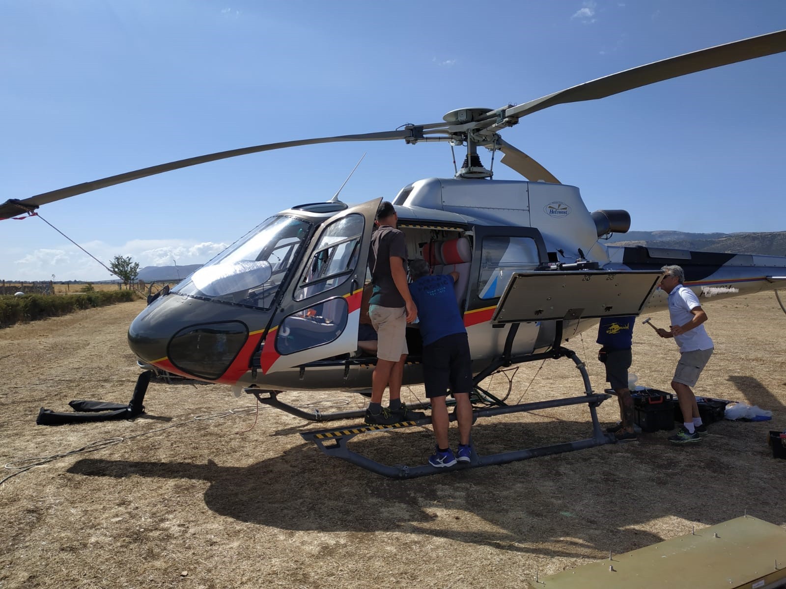
Installation of the radar on the helicopter
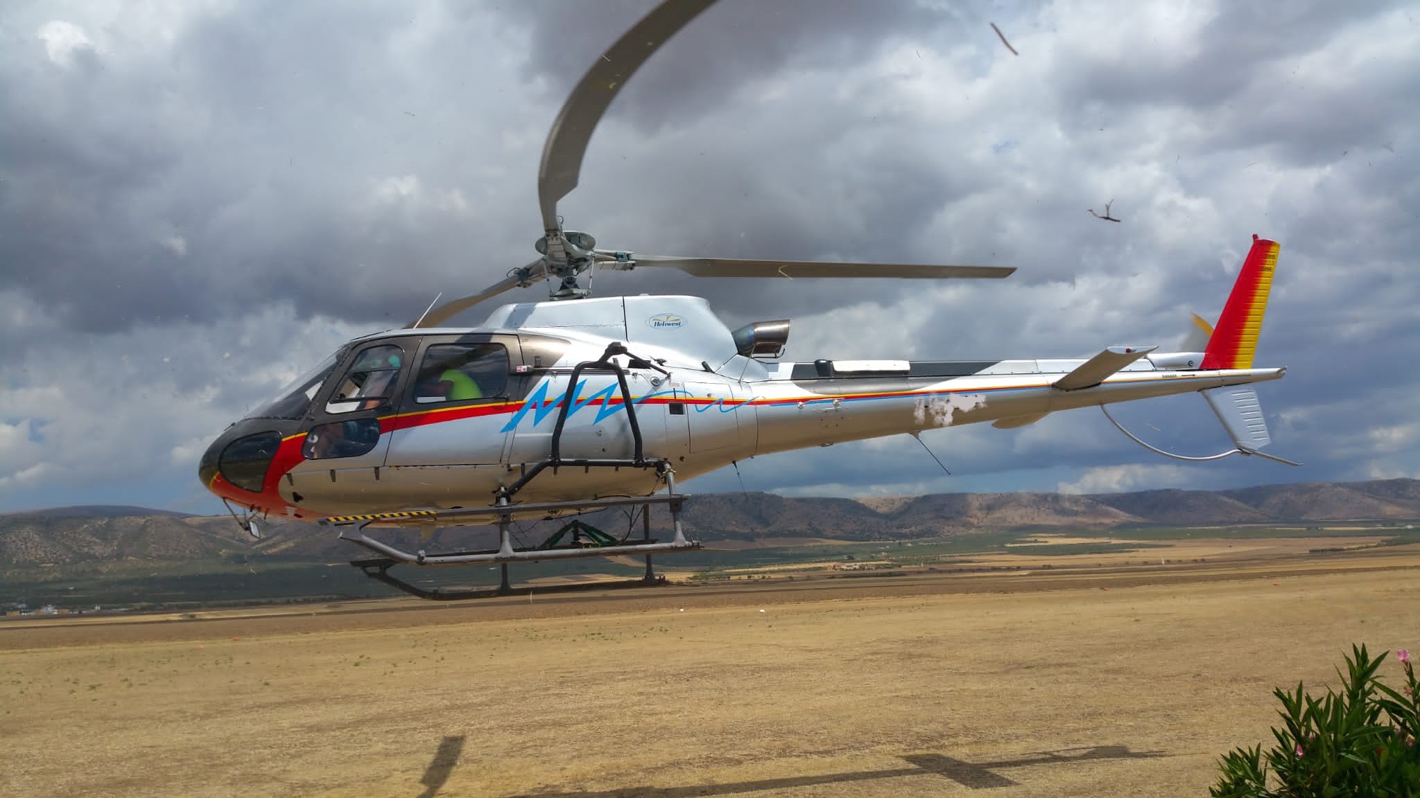
Helicopter in flight
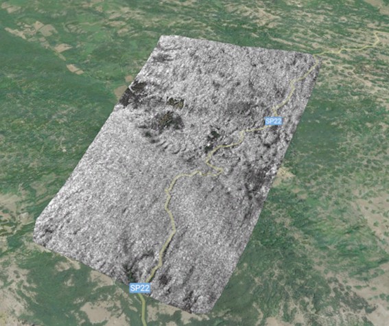
SAR image of the round plain of San Giovanni Rotondo superimposed on a Google Earth image
The RADAR, designed and built in the laboratories of the Corista Consortium as part of a project funded by ASI, was installed on a helicopter that flew over the San Giovanni Rotondo plain.
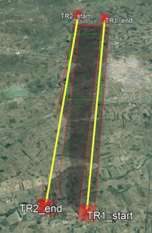
Flight tracks
The instrument, of dimensions 50cm x 50cm x 60cm, for a weight of about 35kg, is mainly composed of an electronic and a radiofrequency part, mounted in a rack, and an antenna. The campaign lasted two days during which flights were carried out at different times of the day in order to monitor the soil moisture conditions in different time slots.
STRATIFY Project
The objective is to develop and verify a software tool aimed to perform end-to-end (E2E) simulation for flexible VHTS (Very High Throughput Satellite) satellite embarking a complex antenna driven by a digital processor based on Digital Transparent Processing (DTP) architecture. The antenna has to be capable to provide, in the coverage area, a huge number of spot-beam and the allocation of the resource between spot-beam and/or cluster of them has to be flexible and configurable in the time. The DTP will mainly based on Software Define Radio (SDR) technology and will host a Digital Beam Forming Network (DBFN) driving the antenna.
STRATIFY is funded by ESA in the framework of the ARTES programme. The consortium is composed by Thales Alenia Space Italia as prime contractor and study coordinator, CO.RI.S.T.A., University of Bari and two South Italy SMEs, named WISER and AI2.
CO.RI.S.T.A. is in charge of developing Payload Module Emulator, based on on-board Digital Transparent Processor (DTP).
FLY-RADAR
FLY-RADAR project deals with the production of a dual-mode, low-frequency, radar installed on board of a light-weight UAV. The radar will operate into two modes: as Synthetic Aperture Radar (SAR) and as ground penetrating radar. Both instruments provide extremely interesting images that are extensively used in Earth and planetary observations. FLY-RADAR is funded by EU.
CO.RI.S.T.A. is in charge of developing a miniaturized low-frequency RADAR, multi-mode and multi-band, to be installed on drone system. Integrated system, radar and drone, will be verified through flight campaigns aimed to assess its actual performances for geological applications.
Rapporto Aerospazio Campania 2021
CO.RI.S.T.A. expertise and competencies described in Rapporto Aerospazio Campania 2021, published on La Repubblica – April 2021.

Achievement Award received from the Argentina space agency CONAE (Comisión Nacional de Actividades Espaciales) for the collaboration, effort and commitment lavished by CORISTA for the completion of the Argentine satellite constellation SAOCOM.
CO.RI.S.T.A. participates in the OT4CLIMA project
Development of innovative Earth Observation technologies for the study of climate change and its impacts on the environment and territory
The general objective of the OT4CLIMAproject is to develop new measurement instruments and new Earth Observation methodologies to provide products / applications / services aimed at improving the mitigation capabilities of the effects of Climate Change (CC) on the regional and sub-scale regional.
The project stems from the awareness that the impacts of current CCs on the environment and the territory need to be better understood, modeled and observed, even on the local and regional scale in order to implement appropriate and effective mitigation strategies. It tries to respond to some of the challenges still open, identified by the main international initiatives (eg CEOS WG Climate, GCOS) as Recommendations and Actions for the coming years, such as, for example, the use of new observation technologies, the observation of additional climatic parameters as well as the development of new analysis techniques (see GCOS 2016 Implementation Plan).

CO.RI.S.T.A. sponsor of SPACE APPS CHALLENGE 2019 - NAPLES

#SpaceApps is the largest hackathon in the world promoted by NASA in over 180 cities around the world, and sees our city host it for the fifth consecutive year.
The event will be held on 19 and 20 October at the San Giovanni a Teduccio pole of the Federico II University, Naples. Here, young high school and university students from our region will meet with the aim of producing innovative ideas and solutions on key issues ranging from climatology to space exploration, from robotics to mining on asteroids, based on an approach of collaborative and open-source problem solving. A jury will evaluate the works proposed by the various groups and the top three, in addition to cash prizes, will be able to participate in the national selection that will bring the winners to the States.
This year the theme of Space Apps 2019 is "Exploring Near and Far" in the following 5 categories:
- Earth's Oceans
- Our Moon
- Planets Near And Far
- To The Stars
- Living In Our World
Rapporto Aerospazio Campania 2018
CO.RI.S.T.A. expertise and competencies described in Rapporto Aerospazio Campania 2018, published on La Repubblica – Napoli, February 28th 2018
CO.RI.S.T.A.: Esplorando Marte e la Terra con gli occhi dei radar
FOLDOUT
CO.RI.S.T.A. participates in the program FOLDOUT (Through-foliage detection, including in the outermost regions of the EU) funded in the framework of Horizon 2020; Proponent: AIT (Austrian Institute of Technology).
The main goal of FOLDOUT is to develop, test and demonstrate a system and solution to detect and locate people and vehicles operating under the coverage of trees and other foliage over large areas in the inner and outermost regions of the EU.
FOLDOUT will build a system that combines various sensors and technologies and intelligently fuses these into an effective and robust intelligent detection platform. Fusing several sensor signals increases the effectiveness of detection.
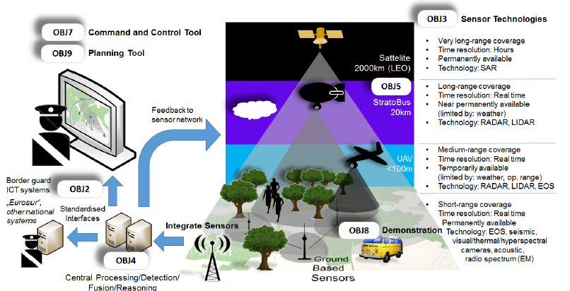
FOLDOUT will make the tasks of Border Guards simpler and faster by combining events from various sensors to give a complete situation threat assessment combined with suggested reaction scenarios. By considering all existing sensor technologies FOLDOUT can be adapted to fulfill the requirements of various scenarios in harsh environments.
A two year pilot in Bulgaria and demonstrators in Greece, Finland and French Guiana FOLDOUT will provide fundamental enhancements in the domain of border surveillance and improved search & rescue scenarios.